

A landmark expansion promises to bring leaders closer to the people. But census data reveals a deeper imbalance: where you live may now determine how much your vote counts.
By Charles Mafa
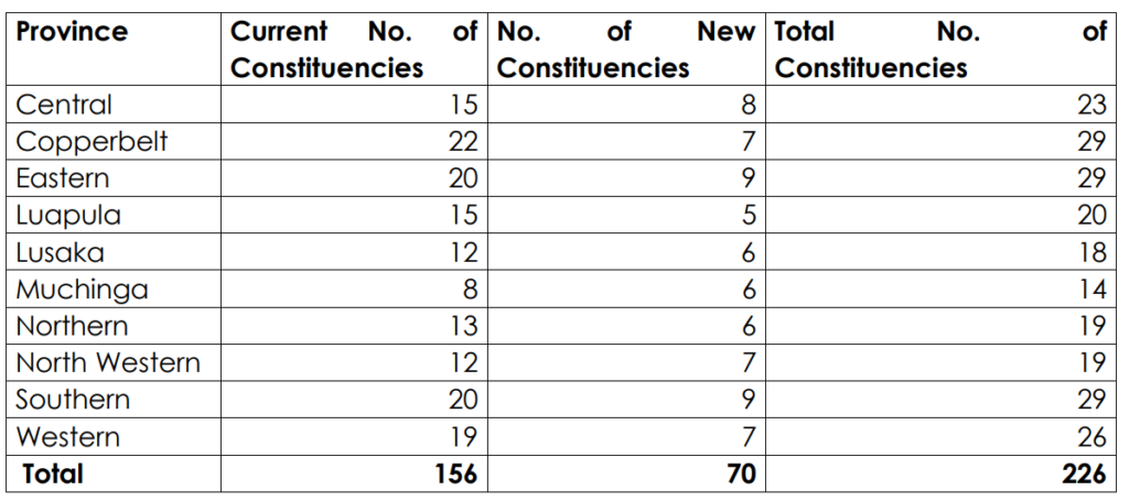
On a morning framed as a milestone for Zambia’s democracy, the Electoral Commission of Zambia (ECZ) unveiled 70 new constituencies, expanding parliament from 156 to 226 seats ahead of the 2026 general election. The announcement was presented as a necessary evolution, one that would bring leadership closer to citizens and respond to population growth across the country.
“In determining the 70 constituencies, the Commission was guided by the factors as outlined in the Constitution which place a duty on the Commission to consider the history, diversity and cohesiveness of communities; population density, trends and projections; geographical features; means of communication; the need to keep constituencies within districts; and the need to pursue approximate equality of population while still protecting adequate representation for urban and sparsely populated areas,’’ said ECZ chairperson Mwangala Zaloumis.
But beneath that promise lies a more complex reality. An analysis by the MakanDay Centre for Investigative Journalism, drawing on the 2022 Census of Population and Housing, shows that the new electoral map does not distribute representation evenly. Instead, it introduces a measurable imbalance between urban and rural Zambia, one that could shape political influence in the years ahead.
Zambia’s population now stands at 19.6 million, according to the 2022 census. With 226 constituencies, this would suggest an average of roughly 86,800 people per constituency, a useful benchmark for what equal representation might look like. Yet the reality deviates sharply from this standard.
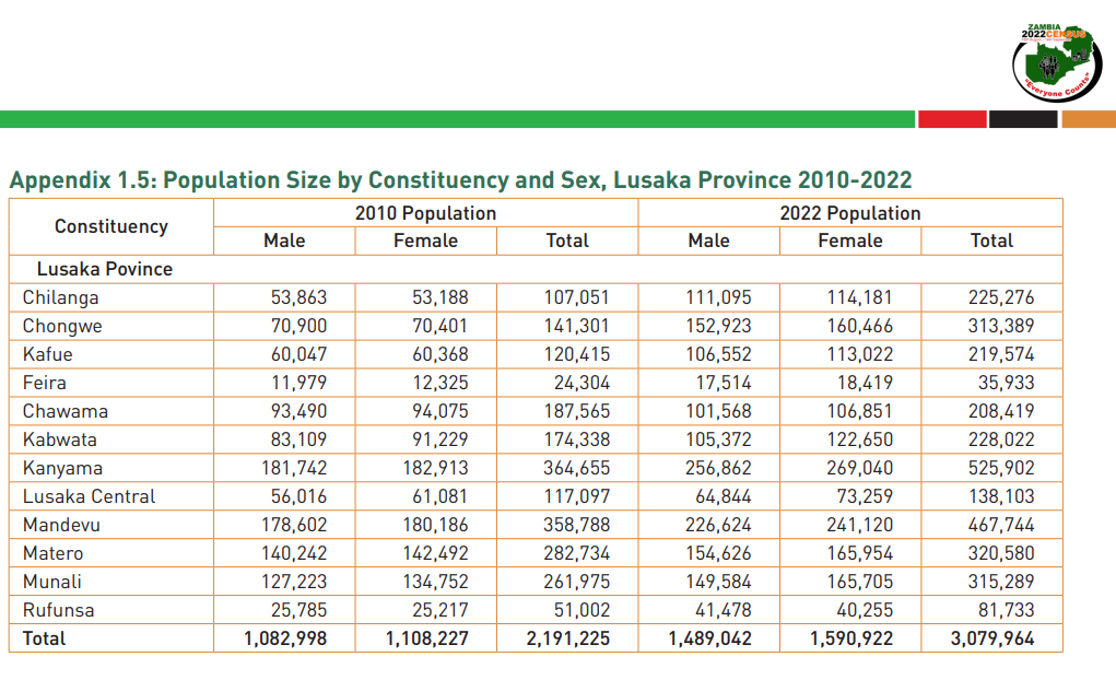
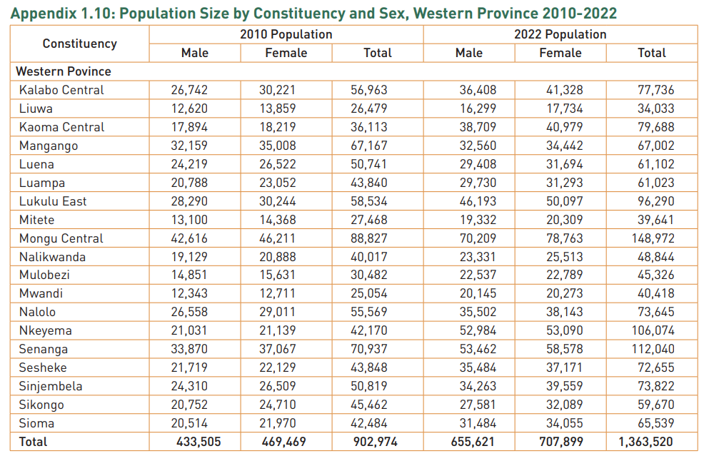
In Lusaka Province, each constituency represents approximately 171,000 people, while in Western Province, a constituency represents just over 52,000. The disparity is not marginal. It means that a vote cast in Western Province carries more than three times the representational weight of one cast in Lusaka.
Source: Zamstats
The ECZ has consistently argued that delimitation is not a mathematical exercise. In her address, Chairperson Zaloumis emphasised that the process was guided not only by population, but also by geography, accessibility, community cohesion, and population trends. These criteria acknowledge the realities of governing a country where some constituencies span vast and difficult terrain, while others are densely packed into urban centres.
Growing faster, represented less
This balancing act is visible in how the new constituencies have been distributed. In urban Zambia, particularly Lusaka, the challenge is population pressure. Lusaka is the country’s largest province, with over three million residents, yet it received only six additional constituencies, bringing its total to 18. The result is a persistently high population per constituency.
In places like Kanyama and Mandevu, populations already exceed several hundred thousand people. Even after subdivision, many urban constituencies remain far above the national average, suggesting that representation has not kept pace with rapid urban growth.
Fewer people, greater weight
Source: Zamstats
In rural Zambia, the logic shifts. Provinces such as Western, North-Western, and Muchinga have smaller populations but significantly lower population-per-constituency ratios. These areas are characterised by large landmass, sparse settlement patterns, and limited infrastructure.
Here, the Commission appears to have prioritised accessibility, ensuring that communities spread across long distances are not left without effective representation. The consequence, however, is that fewer people are represented by each MP, increasing the relative weight of each vote.
Growth corridors
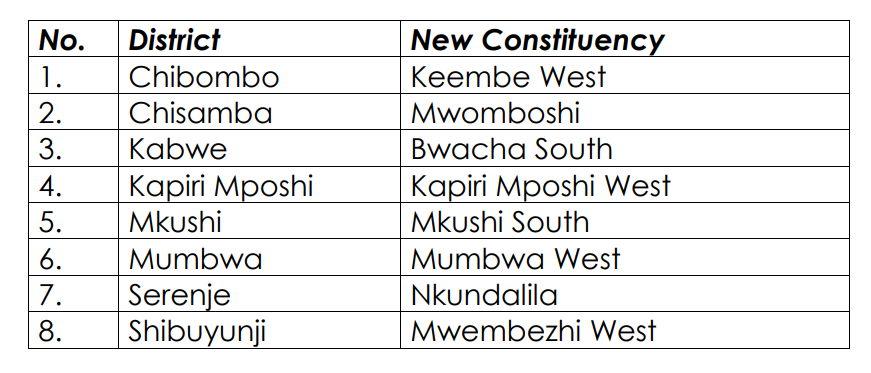
At the same time, the delimitation reflects an awareness of emerging growth corridors. New constituencies have been created in areas such as Chongwe, Kalumbila, and Chibombo, districts that have recorded some of the highest population growth rates in the country.
In these regions, the Commission seems to be anticipating future demographic shifts rather than simply responding to current figures. This forward-looking approach suggests that delimitation is not only about present realities, but also about positioning the electoral map for the Zambia of tomorrow.

According to the 2022 census, these areas have recorded some of the highest growth rates in the country, in some cases exceeding 6–8 percent annually.
A historical shift – with new questions
Historically, the scale of this expansion is unprecedented. Zambia has gradually increased the number of constituencies since independence, but never at this magnitude. The addition of 70 constituencies marks a structural shift in the country’s democratic architecture, one that will influence governance, resource allocation, and political competition for years to come.
Yet it also raises difficult questions about the nature of representation. Should all votes carry equal weight regardless of geography? Or should representation account for the realities of distance, remoteness, and access to services? The current delimitation suggests that Zambia has opted for a hybrid model, one that blends population equality with practical considerations. But in doing so, it has created a system where equality is uneven.
The political stakes
Electoral boundaries are not just administrative tools. They are instruments of power. They determine how communities are grouped, how voices are amplified or diluted, and ultimately how political authority is distributed. In this new configuration, urban voters, despite their growing numbers, find themselves stretched across fewer constituencies, while rural voters gain comparatively greater representation.
The bottom line
The ECZ has delivered on its promise to bring representation closer to the people. But it has not done so equally. As Zambia moves toward the 2026 elections, the new constituencies will not only define political competition, they will quietly shape the value of each vote.
Central Province (8 New Constituencies)
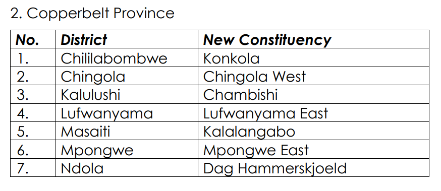
Copperbelt (7 New Constituencies)
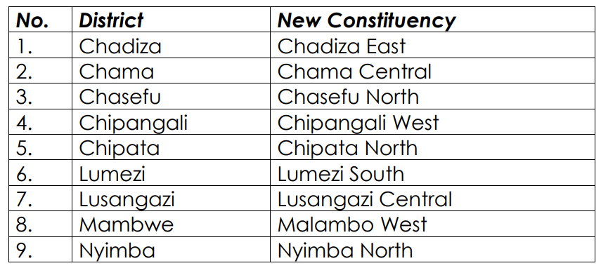
Eastern Province (9 New Constituencies)
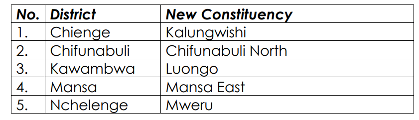
Luapula Province (5 New Constituencies)
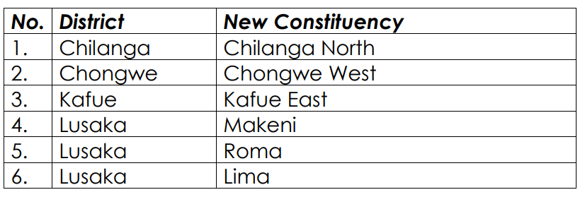
Lusaka Province (6 New Constituencies)
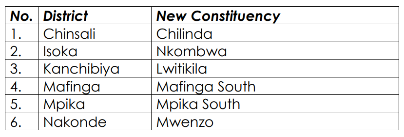
Muchinga Province (6 New Constituencies)
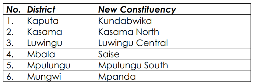
Northern Province (6 New Constituencies)
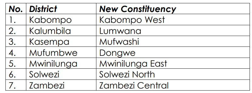
North-Western Province (7 New Constituencies)
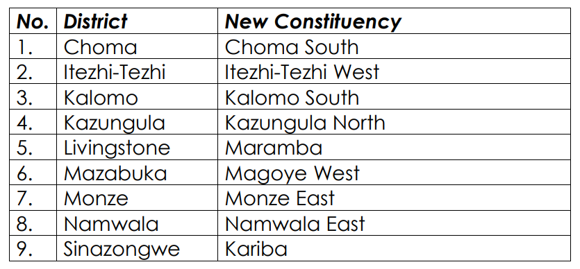
Southern Province (9 New Constituencies)
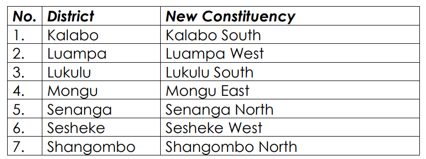
Western Province (7 New Constituencies)

Discover more from MAKANDAY
Subscribe to get the latest posts sent to your email.